
การประยุกต์ใช้อากาศยานไร้คนขับเพื่อใช้ในการประเมินปริมาณค่าการกักเก็บคาร์บอน ในสวนป่าสัก สถานีวนวัฒนวิจัยเชียงราย จังหวัดเชียงราย
Article Sidebar
Main Article Content
บทคัดย่อ
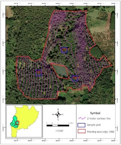
การวิจัยนี้เป็นการประยุกต์ใช้อากาศยานไร้คนขับ (unmanned aerial vehicles, UAV) เพื่อประเมินปริมาณการกักเก็บคาร์บอนในสวนป่าสักของสถานีวนวัฒนวิจัยเชียงราย โดยศึกษาในแปลงปลูกสักปี พ.ศ. 2531 (อายุ 37 ปี) โดยการหาค่าความสูง ของต้นสักจากแบบจาลองความสูงภูมิประเทศเชิงเลข และแบบจาลองความสูงสิ่งปกคลุมพื้นผิวเชิงเลข จากอากาศยานไร้คนขับเปรียบเทียบกับการเก็บข้อมูลภาคสนามโดยวางแปลงสารวจขนาด 40 x 40 เมตร จานวน 3 แปลง เก็บข้อมูลขนาดเส้นผ่านศูนย์เพียงอกและความสูงของต้นสัก ผลการวิจัยพบว่าความสูงจากอากาศยานไร้คนขับมีค่าความสูงเฉลี่ยที่สูงกว่าข้อมูลภาคสนามในแปลงที่ 1 ถึง 3 มีค่าเท่ากับ 1.24 1.78 และ 1.54 เมตร ตามลาดับ มีความคลาดเคลื่อนเฉลี่ยกาลังสอง (RMSE) เท่ากับ 2.14 พบว่าค่าความสูงของทั้ง 2 วิธี มีความสอดคล้องกันค่อนข้างมาก (r2 = 0.88) ปริมาณการกักเก็บคาร์บอนที่ประเมินโดยใช้จากอากาศยานไร้คนขับและจากการสารวจภาคสนาม มีค่าเท่ากับ 30.31 และ 34.51 ตันคาร์บอนต่อเฮกตาร์ ตามลาดับ ค่าประเมินการกักเก็บคาร์บอนที่ได้จากอากาศยานไรคนขับมีสูงกว่าการเก็บข้อมูลภาคสนามเฉลี่ย 4.20 ตันคาร์บอนต่อเฮกตาร์ หรือคิดเป็นร้อยละ 12.89 การนา อากาศยานไร้คนขับมาใช้ในการประเมินการกักเก็บคาร์บอนสามารถช่วยลดระยะเวลาในการสารวจ แต่สิ่งที่ต้องพิจารณาเพิ่มเติม คือเครื่องมือในการจับค่าพิกัดภาคพื้นดินที่ต้องมีความละเอียดสูงเนื่องจากมีผลต่อความสูงของแบบจาลองความสูงลักษณะภูมิประเทศ และการคานวนค่าความสูงของต้นไม้ซึ่งจะส่งผลต่อการประเมินการกักเก็บคาร์บอนที่คลาดเคลื่อนได้
Downloads
Article Details

อนุญาตภายใต้เงื่อนไข Creative Commons Attribution-NonCommercial-NoDerivatives 4.0 International License.
ข้าพเจ้าและผู้เขียนร่วม (ถ้ามี) ขอรับรองว่า ต้นฉบับที่เสนอมานี้ยังไม่เคยได้รับการตีพิมพ์และไม่ได้อยู่ในระหว่างกระบวนการพิจารณาตีพิมพ์ลงในวารสารหรือสิ่งตีพิมพ์อื่นใด ข้าพเจ้าและผู้เขียนร่วม (ถ้ามี) ยอมรับหลักเกณฑ์และเงื่อนไขการพิจารณาต้นฉบับ ทั้งยินยอมให้กองบรรณาธิการมีสิทธิ์พิจารณาและตรวจแก้ต้นฉบับได้ตามที่เห็นสมควร พร้อมนี้ขอมอบลิขสิทธิ์ผลงานที่ได้รับการตีพิมพ์ให้แก่วารสารวนศาสตร์ คณะวนศาสตร์ มหาวิทยาลัยเกษตรศาสตร์ กรณีมีการฟ้องร้องเรื่องการละเมิดลิขสิทธิ์เกี่ยวกับภาพ กราฟ ข้อความส่วนใดส่วนหนึ่ง หรือ ข้อคิดเห็นที่ปรากฏในผลงาน ให้เป็นความรับผิดชอบของข้าพเจ้าและผู้เขียนร่วม (ถ้ามี) แต่เพียงฝ่ายเดียว และหากข้าพเจ้าและผู้เขียนร่วม (ถ้ามี) ประสงค์ถอนบทความในระหว่างกระบวนการพิจารณาของทางวารสาร ข้าพเจ้าและผู้เขียนร่วม (ถ้ามี) ยินดีรับผิดชอบค่าใช้จ่ายทั้งหมดที่เกิดขึ้นในกระบวนการพิจารณาบทความนั้น”
เอกสารอ้างอิง
Ahmad, F., Goparaju, L., Qayum, A. 2017. Natural resource mapping using Landsat and LIDAR towards identifying digital elevation, digital surface and canopy height models. International Journal of Environmental Sciences & Natural Resources, 2(1): 30–37. DOI: 10.19080/IJESNR.2017.02.555580.
Chiang Rai Silvicultural Research Station. 2023. Annual performance report 2023. Forest Resource Management Office No. 2 (Chiang Rai), Royal Forest Department
Iamsaard, P., Apinyarat, W., Chaengchan, S., Chuleut, P., Obphaet A. 2020. Three-dimensional modeling for tree volume determination using unmanned aerial vehicles: a case study of foxtail trees. The 25th National Convention on Civil Engineering. July 15-17, 2020, Chonburi, THAILAND. SGIO7-1– SGIO7-7 pp.
IPCC 2006. IPCC Guidelines for National Greenhouse Gas Inventories, Preparedby the National Greenhouse Gas Inventories Programme, Eggleston H.S., Buendia L., Miwa K., Ngara T. and Tanabe K. (eds). Published: IGES, Japan
Kaartinen, H., Hyyppä, J., Yu, X., Vastaranta, M., Hyyppä, H., Kukko, A., Holopainen, M., Heipke, C., Hirschmugl, M., Morsdorf, F., Næsset, E., Pitkänen, J., Popescu, S., Solberg, S., Wolf, B. M., Wu, J.C. 2012. An international comparison of individual tree detection and extraction using airborne laser scanning. Remote Sensing, 4(4): 950–974. DOI: 10.3390/rs4040950.
Khosravipour, A., Skidmore, A. K., Wang, T., Isenburg, M., Khoshelham, K. 2015. Effect of slope on treetop detection using a LiDAR Canopy Height Model. ISPRS Journal of Photogrammetry and Remote Sensing, 104: 44-52. DOI: 10.1016/j.isprsjprs.2015.02.013.
Krause S, Tanja GMS, Jan PM, Klaus G. 2019. UAV-based photogrammetric tree height measurement for intensive forest monitoring. Remote Sens, 11(7): 1-19. DOI: 10.3390/rs11070758.
Larjavaara M, Helene CM. 2013. Measuring tree height: A quantitative comparison of two common field methods in a moist tropical forest. Methods Ecol Evol, 4(9): 793-801. DOI: 10.1111/2041-210X.12071.
Lu N, Jie Z, Zixu H, Dong L, Qiang C, Xia Y, Yongchao T, Yan Z, Weixing C, Tao C. 2019. Improved estimation of aboveground biomass in wheat from RGB imagery and point cloud data acquired with a low-cost unmanned aerial vehicle system. Plant Methods, 15(1): 1-16. DOI: 10.1186/s13007-019-0402-3.
Mohan, M., Silva, C. A., Klauberg, C., Jat, P., Catts, G., Cardil, A., Dia, M. 2017. Individual tree detection from unmanned aerial vehicle (UAV) derived canopy height model in an open canopy mixed conifer forest. Forests, 8(9): 340. https://doi.org/10.3390/f8090340
Ngernin, H. 2018. Quantification of carbon sequestration of Teak areas with UAV (Unmanned Aerial Vehicle) in Amphoe Wang Thong, Phitsanulok. Thesis B.S. in Geography, Naresuan University, Phitsanulok, Thailand. (in Thai)
Rinnamang, S., Sirirueang, K., Supavetch, S., Meunpong, P. 2020. Estimation of aboveground biomass using aerial photogrammetry from unmanned aerial vehicle in teak (Tectona grandis) plantation in Thailand. Biodiversitas Journal of Biological Diversity, 21(6): 2369–2376. DOI: 10.13057/biodiv/d210605.
Panagiotidis D, Azadeh A, Peter S, Vasco C. 2017. Determining tree height and crown diameter from high-resolution UAV imagery. IntlJ Remote Sens, 38(8-10): 2392-2410. DOI: 10.1080/01431161.2016.1264028.
Penboon, C., Supavetch, S., Sirirueang, K., Rinnamang, S., Ladpala, P., Kaewgrajang, T., Meunpong, P. 2023. Estimation of the aboveground biomass and carbon sequestration in an urban forest remnant using aerial photogrammetry from a low-cost Unmanned Aerial Vehicle. Biodiversitas Journal of Biological Diversity, 24(3): 1908–1915. DOI: 10.13057/biodiv/d240368.
Wiriyabuncha, C., Rattanaporncharoen, W., Mungkararat, J., Piananurak, P. 2004. Biomass and growth of some economically important tree species for estimating carbon accumulation in forest plantations. Research paper presented at the Conference on Climate Change and Forestry: Forests and Climate Change. Maruay Garden Hotel, Bangkok, Thailand, August 16–17, 2004. Department of National Parks, Wildlife and Plant Conservation, Bangkok, Thailand. (In Thai)
Zarco-Tejada PJ, Diaz-Varela R, Angileri V, Loudjani P. 2014. Tree height quantification using very highresolution imagery acquired from an Unmanned Aerial Vehicle (UAV) and automatic 3D photo-reconstruction methods. Eur J Agron, 55: 89-99. DOI: 10.1016/j.eja.2014.01.004.
