
การประยุกต์ภูมิสารสนเทศศาสตร์ เพื่อประเมินอัตราการเปลี่ยนแปลง และแนวโน้มการเปลี่ยนแปลงชายฝั่ง บริเวณอุทยานแห่งชาติสิรินาถ จังหวัดภูเก็ต
Article Sidebar
Main Article Content
บทคัดย่อ
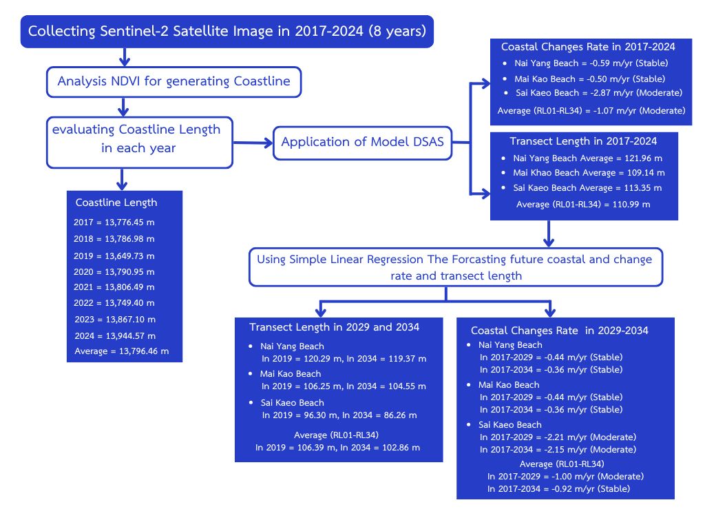
ชายฝั่งทะเลบริเวณอุทยานแห่งชาติสิรินาถ จังหวัดภูเก็ต มีการเปลี่ยนแปลงอย่างต่อเนื่องในช่วงหลายปีที่ผ่านมา ส่งผลกระทบต่อระบบนิเวศชายฝั่ง จึงประยุกต์ใช้ระบบสารสนเทศภูมิศาสตร์เพื่อวิเคราะห์การเปลี่ยนแปลงเส้นชายฝั่ง (Coastline) ปี ค.ศ. 2017-2024 โดยใช้ดัชนี NDVI (Normalized difference vegetation index) และระบบการวิเคราะห์เส้นชายฝั่งดิจิตอล (Digital shoreline analysis system, DSAS) เพื่อวิเคราะห์ความกว้างของชายฝั่ง และอัตราการเปลี่ยนแปลงชายฝั่ง รวมถึงการคาดการณ์แนวโน้มการเปลี่ยนแปลงในอนาคตโดยใช้สมการถดถอยเชิงเส้นอย่างง่าย ผลการศึกษาพบว่า ในปี ค.ศ. 2017-2024 มีความกว้างของชายฝั่งเฉลี่ย เท่ากับ 112.40 เมตร ในส่วนของอัตราการเปลี่ยนแปลงชายฝั่งมีค่าเฉลี่ยเท่ากับ -1.07 เมตร/ปี โดยบริเวณหาดในยาง หาดไม้ขาว และหาดทรายแก้ว มีอัตราการเปลี่ยนแปลงซึ่งอยู่ในเกณฑ์คงสภาพ เท่ากับ -0.59 -0.50 และ -2.87 เมตร/ปี ซึ่งสถานการณ์การเปลี่ยนแปลงชายฝั่งถือว่ามีแนวโน้มคงที่ และการคาดการณ์การเปลี่ยนแปลงชายฝั่งในอนาคต ในปี ค.ศ. 2029 และปี ค.ศ. 2034 มีความกว้างชายฝั่งเฉลี่ย เท่ากับ 106.39 และ 102.86 เมตร ตามลำดับ และอัตราการเปลี่ยนแปลงชายฝั่งของปี ค.ศ. 2017-2029 และปี ค.ศ. 2017-2034 เท่ากับ -1.00 และ -0.92 เมตร/ปี ตามลำดับ ซึ่งผลการศึกษาข้างต้นจะทำให้หน่วยงานภาคต่าง ๆ สามารถกำหนดนโยบายการใช้ประโยชน์พื้นที่ชายฝั่งอย่างเหมาะสม เช่น การจัดเขตการใช้ที่ดิน (Zoning) และการพัฒนาโครงสร้างพื้นฐาน รวมทั้งสามารถนำผลการวิจัยไปใช้ในการสร้างความเข้าใจให้กับประชาชนในพื้นที่เสี่ยง ช่วยให้การมีส่วนร่วมของชุมชนในการจัดการชายฝั่งมีข้อมูลรองรับอย่างเป็นระบบ
Article Details
เอกสารอ้างอิง
Director of Environmental Geology Division.,2021, Reporton Coastal Changes in the Gulf of Thailand: Areas of Laem Klat Subdistrict, Mueang District, and Mai Rut Subdistrict, Khlong Yai District, Trat. Ministry of Natural Resources and Environment, Bangkok, Thailand. (inThai)
Sarajit, O. and Nakhapakorn, K., 2014, Geo-information Application for Coastal Erosion Situation, Phetchaburi Province. pp. 789-800. In Thai Science and Technology Journal, Thammasat University, Pathum Thani, Thailand. (in Thai)
Coastal Community and Network Management Division., 2015, Report on Coastal Erosion Database Compilation for 23 Provinces. Department of Marine and Coastal Resources, Ministry of Natural Resources and Environment, Bangkok, Thailand. (in Thai)
Department of Marine and Coastal Resources. Coastal Erosion Situation in Phuket, Available Source: https://km.dmcr.go.th/c_1/s_405/d_19078,February 15, 2025. (in Thai)
Plangngan, P., 2015, Coastal Erosion Situation in Sirinart National Park. pp. 204-211. In Academic Conferences and Academic Presentations of 4 th Thai Forest Ecological Research Network (T-FERN), Faculty of Agriculture, Natural Resources and Environment Naresuan University, Phitsanulok, Thailand. (inThai)
Sirinat National Park., 2022, Sirinath National Park Area Management Plan (in 2023-2027). Department of National Parks, Wildlife and Plant Conservation, Bangkok. (in Thai)
Khunrattanasiri, W. and Thoenglom, Y., 2023, Prediction of teak volume using sentinel-2 satelliteimagery dataat thong pha phum plantation, Kanchanaburi Province. J. Agric. Res. Ext. 40 (2):130-145. (in Thai)
Pholgerddee, P., 2019, The Application of Geo-Infomatics Technology for the Vegetation Index and Humidity Study: A Case Study Analysis of Drought in The Special Economic Eastern Region. Faculty of Geoinformatics, Burapha University, Chonburi. Thailand. (in Thai)
Department of Marine and Coastal Resources., 2023, Status of Coastal Changes in Thailand from 1972 to 2022. Department of Marine and Coastal Resources, Bangkok. (in Thai)
Sannatai, N., 2023, The Projection of Shoreline Changes in Tourism Beaches, Phuket Province. Department of Water Resources Engineering, Kasetsart University, Bangkok. (in Thai)
Pattanaphokrattana, R., 2024, Study of Shoreline Change Using Geographic Information System: A Case Study at Sakom Beach Cell, Songkha Province. Master Thesis, Faculty o f Engineering, Chulalongkorn University. Bangkok. (in Thai)
Surijamorn, K., 2019, Shoreline changes in Ban Laem District, Phetchaburi Province from 1990-2019. Department of Marine Science, Faculty of Science, Chulalongkorn University, Bangkok. (in Thai)
Faiboon, A. and Sangmanee, W., 2019, Geospatial monitoring and forecasts of coastal engineering structures’ shoreline transformational impactat songkhlalake mouth, Prin. Naradhiwas Univ. J. 11(3):165-179. (in Thai)
Sinsakul, S., Tiyapairus, S., Chaimanee, N., Aramprayun, B., 2022, Shoreline Changes in the Gulf of Thailand. Department of Mineral Resources, Ministry of Natural Resourcesand Environment,Bangkok. (in Thai)
Ruksuwan, T., 2014, The Use of Mathematical Model for Analyzing Shoreline Change Rate and Forcast Shoreline A Case Study: Singhanakorn District,SongkhlaProvince, MasterThesis, Prince of Songkla University, Songkhla. Thailand. (in Thai)
Himmelstoss, E. A., Henderson, R. E., Kratzmann, M. G. and Farris, A. S., 2018, Digital Shoreline Analysis System (DSAS) Version 5.0 User Guide (U.S. Geological Survey Open-FileReport2018-1179). U.S. Geological Survey, Available Source: https://pubs.usgs.gov/of/2018/1179/ofr20181179.pdf
Vongtanaboon, S., Hancharoen, W., Homya S. and Kurukodt, J., (2018), Coastal Change Assessmentin Sirinath National Park, Thalang District, Phuket Province. Department of Environmental Science, Faculty of Science and Technology, Phuket Rajabhat University, Phuket. (in Thai)
Sannatai , N., Ritphring, S . and Prigboonchan, S., 2022, Shoreline Changes Along Phuket Island. In The 19 th KU KPS National Conference, Kasetsat University Kamphaeng Saen Campus, Nakhon Pathom, Thailand. (in Thai)
