
การประยุกต์ใช้ระบบสารสนเทศภูมิศาสตร์เพื่อศึกษารูปแบบการเปลี่ยนแปลง การใช้ประโยชน์ที่ดินที่ส่งผลต่อการเกิดไฟป่าในเขตอุทยานแห่งชาติดอยหลวง
Article Sidebar
Main Article Content
บทคัดย่อ
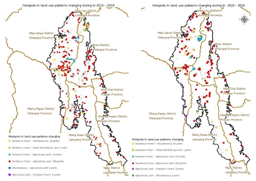
การศึกษารูปแบบการเปลี่ยนแปลงการใช้ประโยชน์ที่ดินที่ส่งผลต่อการเกิดไฟป่าในอุทยานแห่งชาติดอยหลวง มีวัตถุประสงค์ เพื่อประยุกต์ใช้ระบบสารสนเทศภูมิศาสตร์ ในการศึกษารูปแบบการเปลี่ยนแปลงการใช้ประโยชน์ที่ดิน ที่ส่งผลต่อการเกิดไฟป่าในช่วงปี พ.ศ. 2558, พ.ศ. 2562 และ พ.ศ. 2566 ซึ่งอุทยานแห่งชาติดอยหลวง มีพื้นที่ทั้งหมด 1,204.85 ตารางกิโลเมตร จำแนกการใช้ประโยชน์ที่ดินออกเป็น 6 ประเภท ได้แก่ พื้นที่เกษตรกรรม พื้นที่ป่าไม่ผลัดใบพื้นที่ป่าผลัดใบ พื้นที่แหล่งน้ำ พื้นที่ชุมชนและสิ่งปลูกสร้าง และพื้นที่เบ็ดเตล็ด ผลการศึกษา พบว่า ระหว่างปี พ.ศ. 2558–2562 มีการเปลี่ยนแปลงของพื้นที่ทั้งหมด 9.08 ตารางกิโลเมตร โดยพื้นที่ป่าผลัดใบ ลดลงมากที่สุด 4.35 ตารางกิโลเมตร และพื้นที่ที่เพิ่มขึ้นมากที่สุด คือ พื้นที่เกษตรกรรม 3.41 ตารางกิโลเมตร ในปี พ.ศ. 2562 เกิดจุดความร้อนขึ้น 1,805 จุด ซึ่งจำนวนจุดความร้อนที่เกิดขึ้นในพื้นที่ที่มีการเปลี่ยนแปลงรูปแบบการใช้ประโยชน์ที่ดินระหว่างปี พ.ศ. 2558–2562 เกิดขึ้น 279 จุด โดยพื้นที่ป่าผลัดใบที่ถูกเปลี่ยนเป็นพื้นที่เกษตรกรรม เกิดจุดความร้อนมากที่สุด จำนวน 230 จุด คิดเป็นร้อยละ 82.44 และระหว่างปี พ.ศ. 2562–2566 พบว่า มีการเปลี่ยนแปลงของพื้นที่ทั้งหมด 12.16 ตารางกิโลเมตร โดยพื้นที่ป่าผลัดใบ ลดลงมากที่สุด 3.49 ตารางกิโลเมตร ส่วนพื้นที่ที่เพิ่มขึ้นมากที่สุด คือ พื้นที่เกษตรกรรม 5.15 ตารางกิโลเมตร ในปี พ.ศ. 2566 เกิดจุดความร้อนขึ้น 1,812 จุด ซึ่งจำนวนจุดความร้อนที่เกิดขึ้นในพื้นที่ที่มีการเปลี่ยนแปลงรูปแบบการใช้ประโยชน์ที่ดินระหว่างปี พ.ศ. 2562–2566 เกิดขึ้น 285 จุด โดยพื้นที่ป่าผลัดใบที่ถูกเปลี่ยนเป็นพื้นที่เกษตรกรรมเกิดจุดความร้อนมากที่สุด จำนวน 225 จุด คิดเป็นร้อยละ 78.95
Downloads
Article Details

อนุญาตภายใต้เงื่อนไข Creative Commons Attribution-NonCommercial-NoDerivatives 4.0 International License.
ข้าพเจ้าและผู้เขียนร่วม (ถ้ามี) ขอรับรองว่า ต้นฉบับที่เสนอมานี้ยังไม่เคยได้รับการตีพิมพ์และไม่ได้อยู่ในระหว่างกระบวนการพิจารณาตีพิมพ์ลงในวารสารหรือสิ่งตีพิมพ์อื่นใด ข้าพเจ้าและผู้เขียนร่วม (ถ้ามี) ยอมรับหลักเกณฑ์และเงื่อนไขการพิจารณาต้นฉบับ ทั้งยินยอมให้กองบรรณาธิการมีสิทธิ์พิจารณาและตรวจแก้ต้นฉบับได้ตามที่เห็นสมควร พร้อมนี้ขอมอบลิขสิทธิ์ผลงานที่ได้รับการตีพิมพ์ให้แก่วารสารวนศาสตร์ คณะวนศาสตร์ มหาวิทยาลัยเกษตรศาสตร์ กรณีมีการฟ้องร้องเรื่องการละเมิดลิขสิทธิ์เกี่ยวกับภาพ กราฟ ข้อความส่วนใดส่วนหนึ่ง หรือ ข้อคิดเห็นที่ปรากฏในผลงาน ให้เป็นความรับผิดชอบของข้าพเจ้าและผู้เขียนร่วม (ถ้ามี) แต่เพียงฝ่ายเดียว และหากข้าพเจ้าและผู้เขียนร่วม (ถ้ามี) ประสงค์ถอนบทความในระหว่างกระบวนการพิจารณาของทางวารสาร ข้าพเจ้าและผู้เขียนร่วม (ถ้ามี) ยินดีรับผิดชอบค่าใช้จ่ายทั้งหมดที่เกิดขึ้นในกระบวนการพิจารณาบทความนั้น”
เอกสารอ้างอิง
Congalton, R.G., Green, K. 1999. Assessing the Accuracy of Remotely Sensed Data Principles and Practices. Lewis Publisher, Boca Raton, USA.
Department of National Parks, Wildlife and Plant Conservation. 2022. Doi Luang National Park Management Plan. Bangkok, Thailand. (in Thai)
Forest Protection and Fire Control Office. 2021. Measures to Solve Forest Fire Problems in 2021. Bangkok, Thailand. (in Thai)
Forest Protection and Fire Control Office. 2022. Hotspot Statistics of Thailand in 2020–2022. https://portal.dnp.go.th/Content/firednp?contentId=15705/, 15 January 2023.
Kongsawi, V., Arunpraparut, W., Rianthakool, L. 2020. Application of geo–informatics in predicting forest land use at the Doi Inthanon National Park, Chiang Mai province. Thai Journal of Forestry, 39(2): 77–90. (in Thai)
Land Development Department. 2003. Land Use Classification Document. Bangkok, Thailand. (in Thai)
Lillesand, T., Kiefer, R.W., Chipman, J. 2015. Remote Sensing and Image Interpretation. Wiley, New York, USA.
Nation Aeronautics and Space Administration. 2024. Fire Information for Resource Management System. https://firms.modaps.eosdis.nasa.gov/, 1 January 2024.
Royal Forest Department. 2021. Project to Prepare Information on the Condition of Forest Areas in the Year 2020–2021. Bangkok, Thailand. (in Thai)
Royal Forest Department. 2022. Project to Prepare Information on the Condition of Forest Areas in the Year 2021–2022. Bangkok, Thailand. (in Thai)
Sinrodtanakorn, C., Arunpraparut, W., Pongpattananurak, N. 2020. Monitoring and predicting land use tendency using land change modeler at Doi Suthep–Pui National Park, Chiang Mai province. Thai Journal of Forestry, 39(1): 110–124. (in Thai)
Suwanwaree, T., Phayungwiwatthanakoon, C. 2015. Impacts of Forest Fire on the Forest Fertility and Air Quality in Chiang Mai Province. Suranaree University of Technology, Nakhon Ratchasima, Thailand. (in Thai)
Zea–kow, C., Rachdawong, P., Charoenpol, K. 2022. Statistical analysis of factors affecting the onset of forest fires in Nan province. Chulachomklao Royal Military Academy Journal, 20(1): 1–11. (in Thai)
