Application of Geographic Information System to Study Land Use Change Patterns in Response to Forest Fires in Doi Luang National Park
Article Sidebar
Main Article Content
Abstract
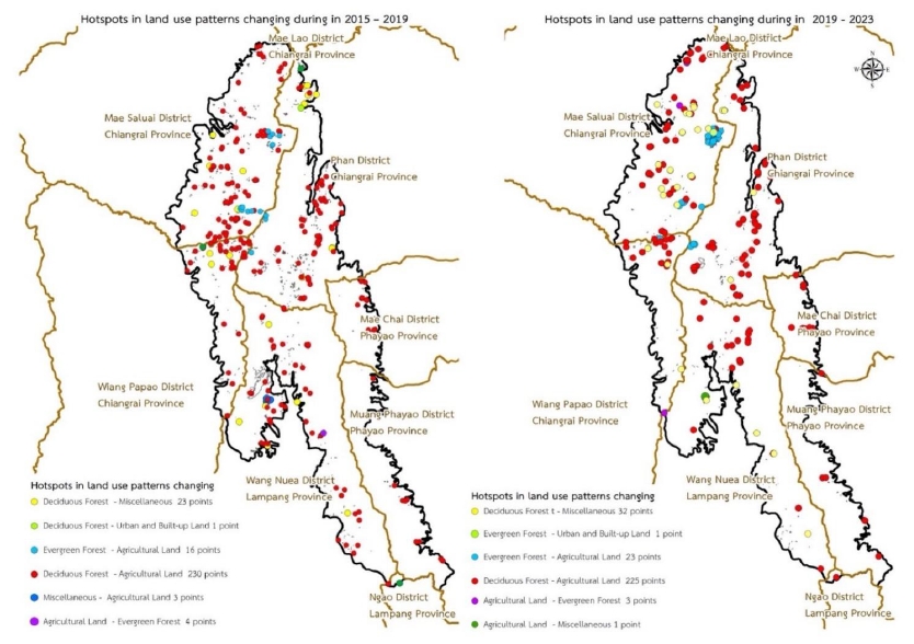
Land use change patterns and their effects on forest fire occurrence were studied in Doi Luang National Park using data in a geographic information system for 2015, 2019 and 2023. Based on the results of the study, Doi Luang National Park had an area of 1,204.85 square kilometers. The land use was classified into 6 patterns: agricultural areas, evergreen forest, deciduous forest, water body, urban and built–up land, and miscellaneous. From 2015 to 2019, there was a total change of 9.08 square kilometers, with the greatest decrease in deciduous forest (about 4.35 square kilometers), while agricultural areas increased by 3.41 square kilometers. In 2019, there were 1,805 hotspots, of which 279 were in areas with changing land use patterns between 2015 and 2019. The greatest number of hotspots (230) occurred in deciduous forests that had been converted to agricultural areas, representing 82.44%. From 2019 to 2023, there was a total change of 12.16 square kilometers, with the greatest decrease in deciduous forest (about 3.49 square kilometers), while agricultural areas increased by 5.15 square kilometers. In 2023, there were 1,812 hotspots, of which 285 occurred in areas with changing land use patterns between 2019 and 2023. The greatest number of hotspots (255) occurred in deciduous forest, representing 78.95%.
Downloads
Article Details

This work is licensed under a Creative Commons Attribution-NonCommercial-NoDerivatives 4.0 International License.
ข้าพเจ้าและผู้เขียนร่วม (ถ้ามี) ขอรับรองว่า ต้นฉบับที่เสนอมานี้ยังไม่เคยได้รับการตีพิมพ์และไม่ได้อยู่ในระหว่างกระบวนการพิจารณาตีพิมพ์ลงในวารสารหรือสิ่งตีพิมพ์อื่นใด ข้าพเจ้าและผู้เขียนร่วม (ถ้ามี) ยอมรับหลักเกณฑ์และเงื่อนไขการพิจารณาต้นฉบับ ทั้งยินยอมให้กองบรรณาธิการมีสิทธิ์พิจารณาและตรวจแก้ต้นฉบับได้ตามที่เห็นสมควร พร้อมนี้ขอมอบลิขสิทธิ์ผลงานที่ได้รับการตีพิมพ์ให้แก่วารสารวนศาสตร์ คณะวนศาสตร์ มหาวิทยาลัยเกษตรศาสตร์ กรณีมีการฟ้องร้องเรื่องการละเมิดลิขสิทธิ์เกี่ยวกับภาพ กราฟ ข้อความส่วนใดส่วนหนึ่ง หรือ ข้อคิดเห็นที่ปรากฏในผลงาน ให้เป็นความรับผิดชอบของข้าพเจ้าและผู้เขียนร่วม (ถ้ามี) แต่เพียงฝ่ายเดียว และหากข้าพเจ้าและผู้เขียนร่วม (ถ้ามี) ประสงค์ถอนบทความในระหว่างกระบวนการพิจารณาของทางวารสาร ข้าพเจ้าและผู้เขียนร่วม (ถ้ามี) ยินดีรับผิดชอบค่าใช้จ่ายทั้งหมดที่เกิดขึ้นในกระบวนการพิจารณาบทความนั้น”
References
Congalton, R.G., Green, K. 1999. Assessing the Accuracy of Remotely Sensed Data Principles and Practices. Lewis Publisher, Boca Raton, USA.
Department of National Parks, Wildlife and Plant Conservation. 2022. Doi Luang National Park Management Plan. Bangkok, Thailand. (in Thai)
Forest Protection and Fire Control Office. 2021. Measures to Solve Forest Fire Problems in 2021. Bangkok, Thailand. (in Thai)
Forest Protection and Fire Control Office. 2022. Hotspot Statistics of Thailand in 2020–2022. https://portal.dnp.go.th/Content/firednp?contentId=15705/, 15 January 2023.
Kongsawi, V., Arunpraparut, W., Rianthakool, L. 2020. Application of geo–informatics in predicting forest land use at the Doi Inthanon National Park, Chiang Mai province. Thai Journal of Forestry, 39(2): 77–90. (in Thai)
Land Development Department. 2003. Land Use Classification Document. Bangkok, Thailand. (in Thai)
Lillesand, T., Kiefer, R.W., Chipman, J. 2015. Remote Sensing and Image Interpretation. Wiley, New York, USA.
Nation Aeronautics and Space Administration. 2024. Fire Information for Resource Management System. https://firms.modaps.eosdis.nasa.gov/, 1 January 2024.
Royal Forest Department. 2021. Project to Prepare Information on the Condition of Forest Areas in the Year 2020–2021. Bangkok, Thailand. (in Thai)
Royal Forest Department. 2022. Project to Prepare Information on the Condition of Forest Areas in the Year 2021–2022. Bangkok, Thailand. (in Thai)
Sinrodtanakorn, C., Arunpraparut, W., Pongpattananurak, N. 2020. Monitoring and predicting land use tendency using land change modeler at Doi Suthep–Pui National Park, Chiang Mai province. Thai Journal of Forestry, 39(1): 110–124. (in Thai)
Suwanwaree, T., Phayungwiwatthanakoon, C. 2015. Impacts of Forest Fire on the Forest Fertility and Air Quality in Chiang Mai Province. Suranaree University of Technology, Nakhon Ratchasima, Thailand. (in Thai)
Zea–kow, C., Rachdawong, P., Charoenpol, K. 2022. Statistical analysis of factors affecting the onset of forest fires in Nan province. Chulachomklao Royal Military Academy Journal, 20(1): 1–11. (in Thai)
