
การประยุกต์ใช้ดัชนีความชุ่มชื้นของดินร่วมกับปัจจัยกายภาพในการประเมินพื้นที่เสี่ยงภัยดินถล่มบริเวณลุ่มน้ำย่อยห้วยแม่อูมองหลวง จังหวัดแม่ฮ่องสอน
Article Sidebar
Main Article Content
บทคัดย่อ
ดินถล่ม เป็น ภัยพิบัติที่เกิดจากเกิดจากการเคลื่อนตัวของมวลดินหรือหินที่ไหลลงมาตามที่ลาดเขาอย่างรวดเร็ว โดยได้รับอิทธิพลจากความลาดชัน และปริมาณน้ำฝนเป็นปัจจัยเร่งในเกิดดินถล่ม ปัจจุบัน การเปลี่ยนแปลงการใช้ประโยชน์ที่ดินบนพื้นที่สูงชัน ซึ่งเป็นพื้นที่ป่าไม้ชั้นคุณภาพลุ่มน้ำชั้นที่ 1 และ 2 จากการบุกรุกแผ้วถางพื้นที่ป่าต้นน้ำเพื่อทำเกษตรเชิงเดี่ยวจำพวกพืชไร่ การเปลี่ยนแปลงสภาพภูมิอากาศ ปริมาณน้ำฝนที่เพิ่มขึ้น ส่งผลต่อปริมาณความชื้นและความสามารถในการรองรับน้ำได้ของพื้นที่ การศึกษานี้มุ่งเน้นการประยุกต์ใช้ค่าดัชนีความชุ่มชื้นของดิน (antecedent precipitation index, API) เพื่อประเมินพื้นที่เสี่ยงภัยดินถล่มในบริเวณลุ่มน้ำย่อยห้วยแม่อูมองหลวง จังหวัดแม่ฮ่องสอน โดยวิเคราะห์ความผันแปรของค่าดัชนีความชุ่มชื้นของดิน และนำมาประยุกต์ใช้ร่วมกับปัจจัยเสี่ยงภัยดินถล่ม โดยใช้วิธีการเปรียบเทียบปัจจัยรายคู่และการถ่วงน้ำหนักในการประเมินความเสี่ยง ภายใต้สภาวะการเปลี่ยนแปลงการใช้ที่ดินและสภาพภูมิอากาศ ตรวจสอบความถูกต้องของผลการประเมิน โดยการเปรียบเทียบกับแผนที่การประเมินความเสี่ยงภัยดินถล่มของกรมทรัพยากรธรณี โดยใช้วิธีความถูกต้องโดยรวม (overall accuracy)
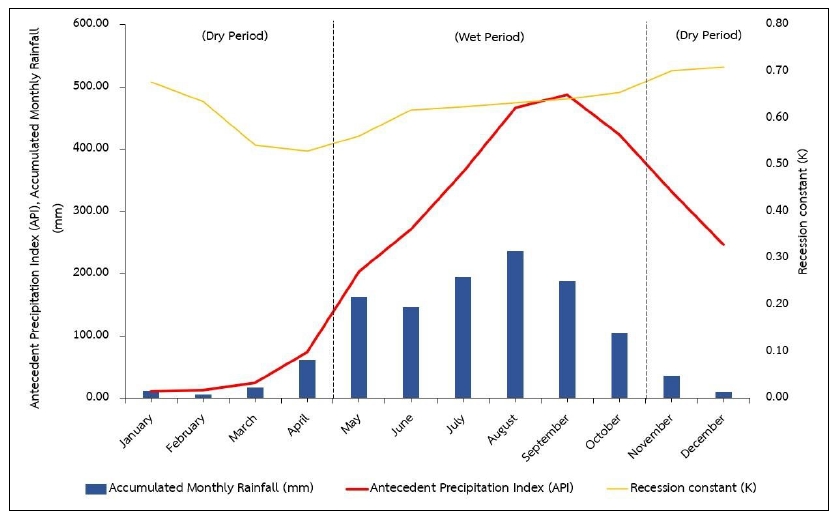
ผลการศึกษาพบว่า ค่าดัชนีความชุ่มชื้นของดินมีค่าสูงสุดที่ 487.18 มิลลิเมตรในเดือนกันยายน และมีค่าต่ำสุดที่ 10.90 มิลลิเมตรในเดือนมกราคม โดยมีค่าเฉลี่ยเท่ากับ 243.33 มิลลิเมตร พื้นที่เสี่ยงภัยดินถล่มในระดับสูงมากมีอัตราส่วนเท่ากับร้อยละ 8.71 ในเดือนสิงหาคม ในเดือนกันยายนและกรกฎาคมมีอัตราส่วนเท่ากับร้อยละ 2.04 และ 1.43 ตามลำดับ การตรวจสอบความถูกต้องโดยรวมมีค่าเท่ากับร้อยละ 90.91 นอกจากนี้ การคาดการณ์ในปี พ.ศ. 2570 พบว่าพื้นที่เสี่ยงภัยดินถล่มจะเพิ่มขึ้นร้อยละ 31.11 ในพื้นที่เกษตรกรรมบนพื้นที่สูง และรอบการเกิดซ้ำ 5 ปี และ 10 ปี พบว่าพื้นที่เสี่ยงภัยดินถล่มจะเพิ่มขึ้นร้อยละ 8.71 และ 8.44 ตามลำดับ ผลการศึกษาสรุปได้ว่า ปริมาณน้ำฝนมีผลกระทบต่อการเกิดดินถล่มมากกว่าการใช้ประโยชน์ที่ดิน ดังนั้นควรมีการจัดการโครงสร้างของระบบนิเวศลุ่มน้ำให้อยู่ในสถานภาพสมดุล เพื่อลดผลกระทบจากการเปลี่ยนแปลงสภาพภูมิอากาศและลดการเกิดดินถล่มในพื้นที่ลุ่มน้ำ
Downloads
Article Details

อนุญาตภายใต้เงื่อนไข Creative Commons Attribution-NonCommercial-NoDerivatives 4.0 International License.
ข้าพเจ้าและผู้เขียนร่วม (ถ้ามี) ขอรับรองว่า ต้นฉบับที่เสนอมานี้ยังไม่เคยได้รับการตีพิมพ์และไม่ได้อยู่ในระหว่างกระบวนการพิจารณาตีพิมพ์ลงในวารสารหรือสิ่งตีพิมพ์อื่นใด ข้าพเจ้าและผู้เขียนร่วม (ถ้ามี) ยอมรับหลักเกณฑ์และเงื่อนไขการพิจารณาต้นฉบับ ทั้งยินยอมให้กองบรรณาธิการมีสิทธิ์พิจารณาและตรวจแก้ต้นฉบับได้ตามที่เห็นสมควร พร้อมนี้ขอมอบลิขสิทธิ์ผลงานที่ได้รับการตีพิมพ์ให้แก่วารสารวนศาสตร์ คณะวนศาสตร์ มหาวิทยาลัยเกษตรศาสตร์ กรณีมีการฟ้องร้องเรื่องการละเมิดลิขสิทธิ์เกี่ยวกับภาพ กราฟ ข้อความส่วนใดส่วนหนึ่ง หรือ ข้อคิดเห็นที่ปรากฏในผลงาน ให้เป็นความรับผิดชอบของข้าพเจ้าและผู้เขียนร่วม (ถ้ามี) แต่เพียงฝ่ายเดียว และหากข้าพเจ้าและผู้เขียนร่วม (ถ้ามี) ประสงค์ถอนบทความในระหว่างกระบวนการพิจารณาของทางวารสาร ข้าพเจ้าและผู้เขียนร่วม (ถ้ามี) ยินดีรับผิดชอบค่าใช้จ่ายทั้งหมดที่เกิดขึ้นในกระบวนการพิจารณาบทความนั้น”
เอกสารอ้างอิง
Ahmad, A., Farida, M., Juita, N. 2022. Spatial analysis of soil texture on risk assessment of hydrometeorology disaster in Rubia–Kelara district of Jeneponto Regency. Journal Wilayah Dan Lingkungan, 10(1): 42–54. doi.org/10.14710/jwl.10.1.42–54
Baiku, P., Tongdeenok, P., Kaewjampa, N. 2021. Application of SWAT and CLUE–S model in streamflow and land use prediction in the upper Khwae–Noi Subwatershed, Nakhonthai district, Phitsanulok province. Thai Journal of Forestry, 40(2): 39–55. (in Thai)
Boonchai, K. 2016. Rotational farming: cultural rights for ecological and social practice. Journal of Social Development, 18(Special Issue): 145–155. (in Thai)
Chantasorn, M. 2012. Comparison of Methodologies for Landslide Susceptibility Assessment at Huai Maephum Watershed, Uttaradit Province. M.S. Thesis, Kasetsart University, Bangkok, Thailand. (in Thai)
Chatsudarat, S. 2021. An Analysis of Spatial Susceptibility and Probability of Rainfall Pattern Inducing Landslides in Northern Thailand with Tropical Rainfall Measuring Mission Data Using GIS. M.S. Thesis, Naresuan University, Bangkok, Thailand. (in Thai)
Centre for SDG Research and Support: SDG Move. 2022. Introduction of SCGs. https://www.sdgmove.com/intro–to–sdgs/, 26 April 2022. (in Thai)
Department of Mineral Resources. 2011. Knowledge of Landslide. http://www.dmr.go.th/download/ Landslide/what_landslide1.htm, 26 April 2022. (in Thai)
Department of Mineral Resources. 2021. Data Landslide of Maehongson. https://www.dmr.go.th/en/ department–of–mineral–resources–thailand/, 28 Mar 2024. (in Thai)
Duangpiboon, S. 2010. Modeling and Spatial Database for Flood and Landslide Risk Assessment: A Case Study of the Lang Suan Watershed, Southern Thailand. M.S. Thesis, Prince of Songkla University, Bangkok, Thailand. (in Thai)
Eastman, J.R. 2003. TerrSet Geospatial Monitoring and Modeling System. Clark University. New York, United States.
Earth Data. 2021. Earthdata Search. https://www.earthdata.nasa.gov/, 2 September 2020. (in Thai)
Hu, J., Yu, Y., Gui, R., Zheng, W., Guo, A. 2023. Spatial distribution analysis of landslide deformations and land–use changes in the three gorges reservoir area by using interferometric and polarimetric SAR. Remote Sensing, 15(2302): 1–21. doi.org/10.3390/rs15092302
Jitpratum, J. 2016. Antecedent Precipitation Index for Early Warning Flood and Landslide in Different Types of Land Use at Huai Mafueang Sub–Watershed, Mueang District, Rayong Province. M.S. Thesis, Kasetsart University, Bangkok, Thailand. (in Thai)
Jumruang, W., Jotisankasa, A., Chayprakaykaew, S. 2022. Development of warning system for landslide hazard area with loT system (internet of things). In: The 27th National Convention on Civil Engineering. Chiang Rai, Thailand, pp. 12–1 – 12–6. (in Thai)
Khiaosalap, P. 2015. Flash Flood and Landslide Risk Area Assessment in Huai Mae Saroi Watershed, Phrae Province and Khlong Tha Thon Watershed, Nakhon Si Thammarat Province. M.S. Thesis, Kasetsart University, Bangkok, Thailand. (in Thai)
Kohno, M., Higuchi, Y. 2023. Landslide susceptibility assessment in the Japanese Archipelago based on a landslide distribution map. International Journal of Geo–Information, 12(37): 1–25.doi.org/10.3390/ ijgi12020037
Land Development Department. 2022. Soil Unit Map. https://dinonline.ldd.go.th/, 18 September 2021. (in Thai)
Land Development Department. 2023. Land Use 2024. https://dinonline.ldd.go.th/, 6 June 2023. (in Thai)
Lekprasoet, R., Tuankrua, V., Kheereemangkla, Y. 2021. Influences of rainfall and antecedent precipitation index on surface runoff generation in Na Luang Sub–watershed, Nan province. Thai Journal of Science and Technology, 10(4): 403–415. (in Thai)
Linsley, R.K., Kohler, M.A., Paulus, J. 1982. Hydrology for Engineers McGraw–Hill Series in Water Resources and Environmental Engineering. McGraw–Hill International, New York, NY, USA.
Mairaing, W., Soralump, S., Jotisankas, A. 2007. Landslides, a Danger that can be Prevented. Kasetsart University, Bangkok, Thailand. (in Thai)
Meteorological Department. 2021. Rainfall Data 2021. Bangkok, Thailand. (in Thai)
Mtibaa, S., Tsunetaka, H. 2023. Revealing the relation between spatial patterns of rainfall return levels and landslide density. Earth Surface Dynamics, 11: 461–474. doi.org/10.5194/esurf–11–461–2023
Naewna Post. 2020. Depression Maehongson Constantly Heavy Rainfall Flash Floods–Landslide. https://www.naewna.com/local/513521, 7 July 2024. (in Thai)
Naewna Post. 2022. Heavy rainfall – Flash Floods in Pang Mapha District. https://www.naewna.com/local/672149, 7 July 2024. (in Thai)
Naewna Post. 2023. Maehongson Warning Flash Floods–Landslide. https://www.naewna.com/local/ 748714, 7 July 2024. (in Thai)
National Science and Technology Development Agency (NSTDA). 2022. What is BCG. https://www.bcg.in.th/, 26 April 2022. (in Thai)
Rajabian, A. 2023. Effect of initial failure geometry on the progress of a retrogressive seepage–induced landslide. International Journal of Geo–Engineering, 14(11): 1–16. doi.org/10.1186/s40703–023–00189–8
Rita, M.D.P.S., Santos, A.L.B., Velloso, M.M. 2023. The use of a booklet in schools to promote landslide prevention. Crossref, 1–10. doi10.56238/sevedi76016–001
Royal Irrigation Department. 2021. Rainfall Data 2021. https://hydro–1.net/, 2 September 2021. (in Thai)
Royal Thai Survey Department. 2021. Topographic Maps 2021. Mae Hong Son, Mae Hong Son province, Thailand. (in Thai)
Saaty, T.L., Vargas, L.G.. 1980. Model, Methods, Concepts & Applications of the Analytic Hierarchy Process. Austin State University, Texas, United States.
Soralump, S., Hunsuwan, B., Torviwat, W. 2007. Analysis of critical API using for warning of heavy rainfall–induced landslide. In: The 12th National Convention on Civil Engineering. Phitsanulok, Thailand, pp. 466 – 473. (in Thai)
Soralump, S., Thaiyuenwong, S. 2009. Study of Landslide–Flood Behavior in the Selected Area for Developing of Warning Method and Criteria (Phase III). Kasetsart University, Bangkok, Thailand. (in Thai)
Soralump, S., Nuimak, T. 2013. Estimation of statistical critical rainfall envelope for landslide warning. In: The 18th National Convention on Civil Engineering. Chiang Mai, Thailand, pp. 322 – 330. (in Thai)
Thummasorn, S. 2020. Coulomb with Physics of Landslide. http://www.thaiphysoc.org/article/227/, 26 April 2024. (in Thai)
Xu, B., Zhang, C., Liu, W., Huang, J., Su, Y., Yang, Y., Jiang, W., Sun, W. 2023. Landslide identification method based on the FKGRNet model for remote sensing images. Remote Sensing, 15(3407): 1–25. doi.org/10.3390/rs15133407
Yongsiri, P., Soytong, P., Laongmanee, W., Uthaisri, P. 2023. Analysis of areas at risk of landslides by applying geospatial technology together with the highest daily rainfall data in 30 years in the Northern Thailand. Journal of Roi Kaensarn Academi, 8(9): 184–199. (in Thai)
