Effects of Land Use Change on Streamflow in the Mae Kham Mee Watershed
Article Sidebar
Main Article Content
Abstract
This study aimed to study land use changes in the Streamflow of Mae Kham Mee Watershed and to examine the impact of land use on runoff volume in the streamflow of Mae Kham Mee watershed. Landsat 8 satellite data from 2016, 2020 and 2024 were analyzed using visual interpretation techniques from a geographic information program.
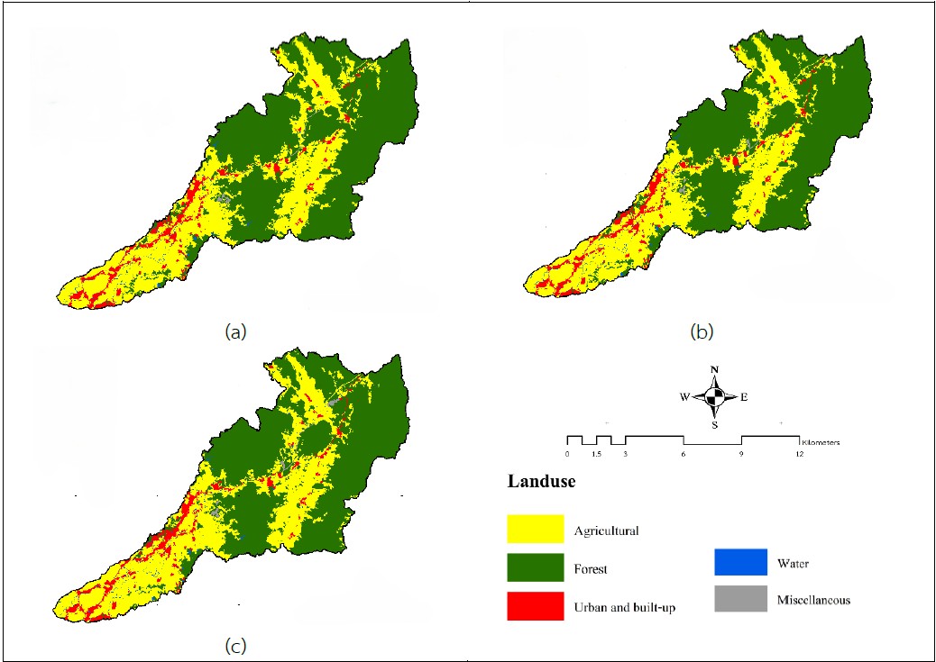
The results of the study, conducted between 2016 and 2024, classified land use into five categories: forest, agricultural, urban and built-up, water, and miscellaneous. The results showed that forest area decreased by 0.74 percent of the total basin area, while agricultural, urban and built-up, miscellaneous and water decreased by 0.38, 0.18, 0.16 and 0.02%, respectively. The classification accuracy was 88.28% and the Kappa coefficient was 0.79. The runoff volume during floods was also high. The dry season runoff volume and the total runoff volume were 120.69, 13.44 and 134.13 MCM, respectively. This represented a runoff volume per basin area of 296,507.78 m³/year/km². The runoff volume or water height was 296.51 mm, resulting in a runoff coefficient of 0.27. The relationship between land use and annual runoff volume indicated that converting forest areas to agricultural areas had no significant effect on total runoff. However, it may have a greater influence on runoff during the flood season than in the dry season in the future
Downloads
Article Details

This work is licensed under a Creative Commons Attribution-NonCommercial-NoDerivatives 4.0 International License.
ข้าพเจ้าและผู้เขียนร่วม (ถ้ามี) ขอรับรองว่า ต้นฉบับที่เสนอมานี้ยังไม่เคยได้รับการตีพิมพ์และไม่ได้อยู่ในระหว่างกระบวนการพิจารณาตีพิมพ์ลงในวารสารหรือสิ่งตีพิมพ์อื่นใด ข้าพเจ้าและผู้เขียนร่วม (ถ้ามี) ยอมรับหลักเกณฑ์และเงื่อนไขการพิจารณาต้นฉบับ ทั้งยินยอมให้กองบรรณาธิการมีสิทธิ์พิจารณาและตรวจแก้ต้นฉบับได้ตามที่เห็นสมควร พร้อมนี้ขอมอบลิขสิทธิ์ผลงานที่ได้รับการตีพิมพ์ให้แก่วารสารวนศาสตร์ คณะวนศาสตร์ มหาวิทยาลัยเกษตรศาสตร์ กรณีมีการฟ้องร้องเรื่องการละเมิดลิขสิทธิ์เกี่ยวกับภาพ กราฟ ข้อความส่วนใดส่วนหนึ่ง หรือ ข้อคิดเห็นที่ปรากฏในผลงาน ให้เป็นความรับผิดชอบของข้าพเจ้าและผู้เขียนร่วม (ถ้ามี) แต่เพียงฝ่ายเดียว และหากข้าพเจ้าและผู้เขียนร่วม (ถ้ามี) ประสงค์ถอนบทความในระหว่างกระบวนการพิจารณาของทางวารสาร ข้าพเจ้าและผู้เขียนร่วม (ถ้ามี) ยินดีรับผิดชอบค่าใช้จ่ายทั้งหมดที่เกิดขึ้นในกระบวนการพิจารณาบทความนั้น”
References
Asanok, L., Lattirasuvan, T. 2015. Tree species composition of plant communities in the Mae Kham Mee Watershed, Phrae Province. In Proceedings of the 5th National Forest Ecology Research Network Conference: Natural resource capital: Value, development, and conservation. Department of National Parks, Wildlife and Plant Conservation; National Park Innovation Institute. (pp. 195–202) (in Thai)
Borabut, A., Phukngam, S. and Keerimongkol, Y. 2021. Effect of Land Use Change on Streamflow of Mae Nam Khuan and Nam Pi Sub-watersheds in Nan and Phayao Provinces. Thai Journal of Forestry, 41(1): 127–138. (in Thai)
Chankaeo, K. 1996. Principles of watershed management. Bangkok: Department of Conservation, Faculty of Forestry, Kasetsart University. (in Thai)
Khunrattanasiri, W., Srikongruk, J., Suksard, S. and Domrongsutsiri, V. 2024a. Comparison of Land Use Classification Methods Using Landsat 9 Data in Eastern Economic Corridor, Thailand. Thai Journal of Forestry, 43(2): 51-61. (in Thai)
Khunrattanasiri, W., Klaylaroen, S. and Suksard, S. 2024b. Using CA-Markov Model and Landsat 8 ImageryData for Land Use Prediction in Thale Noi Non-hunting Area. Thai Journal of Forestry, 43(2): 37-50. (in Thai)
Lattirasuvan, T., Asanok, L., Mangkita, W., Yothaphakdee, T. and Kamtan, R. 2020. Structure and land use change in the Mae Kham Mee Watershed. In: Proceedings of the 9th National Forest Ecology Research Network Conference. Faculty of Forestry, Kasetsart University, January 23-24, 2020. (in Thai)
Makrapirom, P. 1979. Hydrological characteristics of soil related to stream water during dry and wet seasons in natural montane evergreen forests of northern Thailand. Kasetsart University, Bangkok. (in Thai)
Ongsomwang, S. 2016. Remote Sensing System and Digital Image Analysis. Suranaree University of Technology, Nakhon Ratchasima, Thailand. (in Thai)
Office of the National Land Policy Board. 2023. Land Allocation for Communities under the National Land Policy Committee (NLPC), 5th Revised Edition (2nd). Bangkok: Tonkit Create Co., Ltd.
Phaptip, R. 2017. Water yield potential and land use in the Lao River sub-watershed, Chiang Rai Province. Kasetsart University, Bangkok. (in Thai)
Royal Irrigation Department. 2020. Report on streamflow volume in 25 watersheds of Thailand for the year 2018/2019. Bangkok: Royal Irrigation Department, Ministry of Agriculture and Cooperatives. (in Thai).
Saraubon, K. 2020. Learn Data Science AI: Machine Learning with Python. Horsom Media Network, Bangkok, Thailand. (in Thai)
Thongduang, J. 2003. Impacts of land use change and crop water use on water balance and flow characteristics in the Yom River Basin. Kasetsart University, Bangkok. (in Thai)
Wannasin, K., Niyom, W. and Chucheep, K. 2013. Effect of rainfall and land use changes on potential stream flow of upper Nam Ngum river basin, Lao PDR. Thai Journal of Forestry, 32(2): 58-69. (in Thai)
