
Application of Geoinformatics to Assess Coastal Changes and Changing Trends at Sirinat National Park, Phuket
Article Sidebar
Main Article Content
Abstract
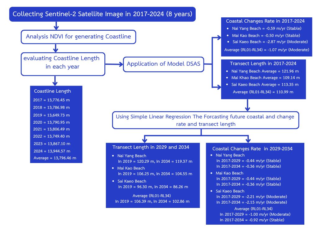
The coastal area of Sirinat National Park in Phuket Province has undergone continuous changes in recent years, impacting the coastal ecosystem. This study employed Geographic Information Systems (GIS) to analyze coastline changes from 2017 to 2024 using the Normalized Difference Vegetation Index (NDVI) and the Digital Shoreline Analysis System (DSAS). These tools were used to assess shoreline width, determine rates of coastal change, and forecast future trends using simple linear regression. The results showed that the average shoreline width between 2017 and 2024 was 112.40 meters, with an average coastal change rate of -1.07 meters per year. At specific locations such as Nai Yang Beach, Mai Khao Beach, and Sai Kaew Beach, the rates of change were -0.59, -0.50, and -2.87 meters per year, respectively, indicating relatively stable conditions. Forecasts for 2029 and 2034 predict average shoreline widths of 106.39 meters and 102.86 meters, respectively, with projected rates of change from 2017 to 2029 and 2017 to 2034 being -1.00and -0.92 meters per year. These findings can assist government agencies and other stakeholders in developing appropriate coastal land-use policies, including zoning and infrastructure planning. Additionally, the results can be used to raise public awareness in at-risk areas and promote community participation in systematic coastal management.
Article Details
References
Director of Environmental Geology Division.,2021, Reporton Coastal Changes in the Gulf of Thailand: Areas of Laem Klat Subdistrict, Mueang District, and Mai Rut Subdistrict, Khlong Yai District, Trat. Ministry of Natural Resources and Environment, Bangkok, Thailand. (inThai)
Sarajit, O. and Nakhapakorn, K., 2014, Geo-information Application for Coastal Erosion Situation, Phetchaburi Province. pp. 789-800. In Thai Science and Technology Journal, Thammasat University, Pathum Thani, Thailand. (in Thai)
Coastal Community and Network Management Division., 2015, Report on Coastal Erosion Database Compilation for 23 Provinces. Department of Marine and Coastal Resources, Ministry of Natural Resources and Environment, Bangkok, Thailand. (in Thai)
Department of Marine and Coastal Resources. Coastal Erosion Situation in Phuket, Available Source: https://km.dmcr.go.th/c_1/s_405/d_19078,February 15, 2025. (in Thai)
Plangngan, P., 2015, Coastal Erosion Situation in Sirinart National Park. pp. 204-211. In Academic Conferences and Academic Presentations of 4 th Thai Forest Ecological Research Network (T-FERN), Faculty of Agriculture, Natural Resources and Environment Naresuan University, Phitsanulok, Thailand. (inThai)
Sirinat National Park., 2022, Sirinath National Park Area Management Plan (in 2023-2027). Department of National Parks, Wildlife and Plant Conservation, Bangkok. (in Thai)
Khunrattanasiri, W. and Thoenglom, Y., 2023, Prediction of teak volume using sentinel-2 satelliteimagery dataat thong pha phum plantation, Kanchanaburi Province. J. Agric. Res. Ext. 40 (2):130-145. (in Thai)
Pholgerddee, P., 2019, The Application of Geo-Infomatics Technology for the Vegetation Index and Humidity Study: A Case Study Analysis of Drought in The Special Economic Eastern Region. Faculty of Geoinformatics, Burapha University, Chonburi. Thailand. (in Thai)
Department of Marine and Coastal Resources., 2023, Status of Coastal Changes in Thailand from 1972 to 2022. Department of Marine and Coastal Resources, Bangkok. (in Thai)
Sannatai, N., 2023, The Projection of Shoreline Changes in Tourism Beaches, Phuket Province. Department of Water Resources Engineering, Kasetsart University, Bangkok. (in Thai)
Pattanaphokrattana, R., 2024, Study of Shoreline Change Using Geographic Information System: A Case Study at Sakom Beach Cell, Songkha Province. Master Thesis, Faculty o f Engineering, Chulalongkorn University. Bangkok. (in Thai)
Surijamorn, K., 2019, Shoreline changes in Ban Laem District, Phetchaburi Province from 1990-2019. Department of Marine Science, Faculty of Science, Chulalongkorn University, Bangkok. (in Thai)
Faiboon, A. and Sangmanee, W., 2019, Geospatial monitoring and forecasts of coastal engineering structures’ shoreline transformational impactat songkhlalake mouth, Prin. Naradhiwas Univ. J. 11(3):165-179. (in Thai)
Sinsakul, S., Tiyapairus, S., Chaimanee, N., Aramprayun, B., 2022, Shoreline Changes in the Gulf of Thailand. Department of Mineral Resources, Ministry of Natural Resourcesand Environment,Bangkok. (in Thai)
Ruksuwan, T., 2014, The Use of Mathematical Model for Analyzing Shoreline Change Rate and Forcast Shoreline A Case Study: Singhanakorn District,SongkhlaProvince, MasterThesis, Prince of Songkla University, Songkhla. Thailand. (in Thai)
Himmelstoss, E. A., Henderson, R. E., Kratzmann, M. G. and Farris, A. S., 2018, Digital Shoreline Analysis System (DSAS) Version 5.0 User Guide (U.S. Geological Survey Open-FileReport2018-1179). U.S. Geological Survey, Available Source: https://pubs.usgs.gov/of/2018/1179/ofr20181179.pdf
Vongtanaboon, S., Hancharoen, W., Homya S. and Kurukodt, J., (2018), Coastal Change Assessmentin Sirinath National Park, Thalang District, Phuket Province. Department of Environmental Science, Faculty of Science and Technology, Phuket Rajabhat University, Phuket. (in Thai)
Sannatai , N., Ritphring, S . and Prigboonchan, S., 2022, Shoreline Changes Along Phuket Island. In The 19 th KU KPS National Conference, Kasetsat University Kamphaeng Saen Campus, Nakhon Pathom, Thailand. (in Thai)
