The survey of sediment quantity from river model by laser triangulation techinque
Article Sidebar
Main Article Content
Abstract
“Laser Triangulation” is considered to be one of the modern techniques to be used in data collection for analysis in various research areas, due to the high resolution, therefore it is suitable to develop further in this area by applying to data collection research from water modeling models for using in data collection and analysis. From calibration research, it has adopted the Laser Triangulation technique to be used for the test of the accuracy of finding the red light of the laser projected by using the “image processing” technique to find the location of the laser from photos taken from the video of the CCD camera with 1080x1920 pixels image size which is from using the “Thresholding” technique to separate the red light of the laser from the photo.
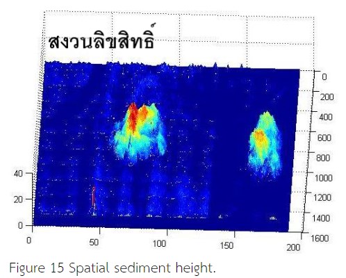
For the reason, this research has developed analytical methods for image analysis with the "RGB" technique instead of the original techniques. The RGB technique can reduce the difficulty of data collecting and also can be used for analyzing to find lasers from photos more clearly to extend to using data for collecting hydraulic model data which can be collected in the form of 3D model data sets in computer programs for the convenience of analyzing, comparing, and storing that data sets. By Tolerances 2.5 pixels or about ± 1.1 mm
Article Details
use or modification of the articles is prohibited without permission.
statements expressed in the articles are solely the opinions of the authors.
authors are fully responsible for the content and accuracy of their articles.
other reuse or republication requires permission from the journal."
