PDF การประเมินขนาดพื้นที่ผิวน้ำในอ่างเก็บน้ำด้วยเทคนิคการวิเคราะห์ภาพถ่ายดาวเทียม
Article Sidebar
Main Article Content
บทคัดย่อ
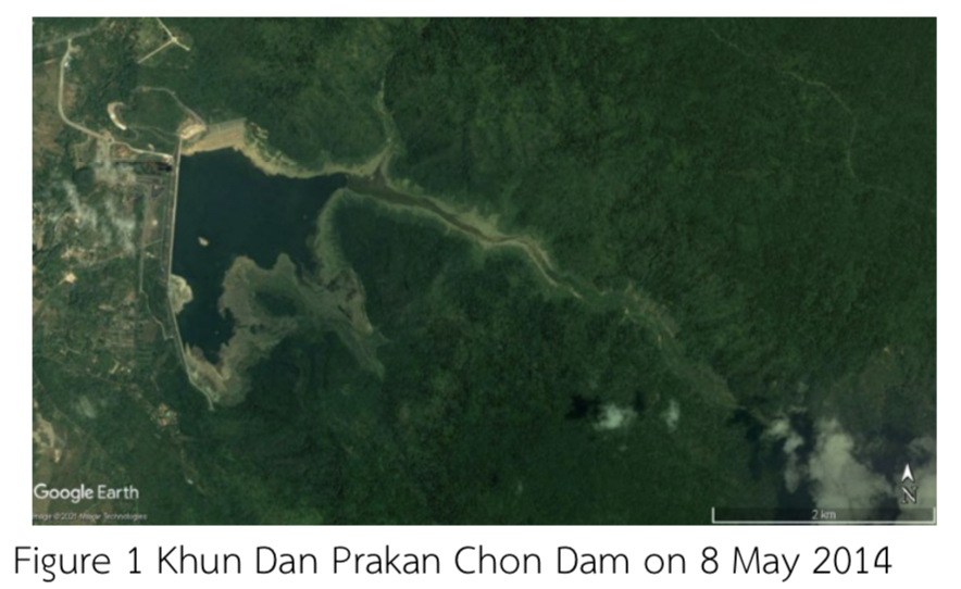
งานวิจัยนี้มีวัตถุประสงค์เพื่อหาพื้นที่ผิวน้ำจากภาพถ่ายดาวเทียมโดยการพัฒนาอัลกอริทึมจากเทคนิควิธีการเรียนรู้เชิงลึกจากภาพถ่ายดาวเทียม Google Earth Pro บริเวณพื้นที่อ่างเก็บน้ำของเขื่อนขุนด่านปราการชล จังหวัดนครนายก จำนวน 3 วัน ประกอบด้วยวันที่ 8 พฤษภาคม 2557, 3 พฤศจิกายน 2560 และ 2 ธันวาคม 2562 วิธีการหาพื้นที่ผิวน้ำดังกล่าว ประกอบด้วย 2 วิธี ได้แก่ การวัดพื้นที่ในโปรแกรม Google Earth Pro และการให้อัลกอริทึมเรียนรู้เชิงลึกแบบวนซ้ำจากการกระจายของสีในภาพถ่ายดาวเทียมสำหรับใช้เป็นข้อมูลสถิติประกอบการตัดสินใจของอัลกอริทึม ซึ่งมีขั้นตอนที่สำคัญ 3 ขั้นตอน คือ 1.การเรียนรู้การตัดแบ่งภาพสีน้ำจริงที่ได้จากภาพถ่ายดาวเทียม 2.การจำแนกระหว่างพื้นที่ผิวน้ำและพื้นที่ที่ไม่ใช่ผิวน้ำ 3.การเรียนรู้การคำนวณหาพื้นที่ผิวน้ำจากภาพถ่ายดาวเทียมของอัลกอริทึม
จากผลการเปรียบเทียบระหว่างการหาพื้นที่ผิวน้ำทั้ง 2 วิธี กับกราฟโค้งความจุของอ่างเก็บน้ำของเขื่อนขุนด่านปราการชล จังหวัดนครนายก พบว่า วิธีการวัดพื้นที่ในโปรแกรม Google Earth Pro มีเปอร์เซ็นต์ความคลาดเคลื่อนเท่ากับ 6.50%, 2.14% และ 1.64% ตามลำดับ ในขณะที่การให้อัลกอริทึมเรียนรู้เชิงลึกแบบวนซ้ำจากการกระจายของสีในภาพถ่ายดาวเทียม มีเปอร์เซ็นต์ความคลาดเคลื่อนเท่ากับ 0.78%, 0.38% และ 0.77% ตามลำดับ ดังนั้น การให้อัลกอริทึมเรียนรู้เชิงลึกแบบวนซ้ำจากการกระจายของสีในภาพถ่ายดาวเทียมมีความแม่นยำและถูกต้องมากกว่า ทำให้สามารถต่อยอดได้โดยการนำไปใช้หาพื้นที่ผิวน้ำของอ่างเก็บน้ำขนาดกลาง หรืออ่างเก็บน้ำขนาดเล็ก ที่ยังไม่มีการจัดทำโค้งความจุของอ่างเก็บน้ำสำหรับใช้ในการบริหารอ่างเก็บน้ำต่อไป
Article Details

อนุญาตภายใต้เงื่อนไข Creative Commons Attribution-NonCommercial-NoDerivatives 4.0 International License.
สมาคมวิศวกรรมเกษตรแห่งประเทศไทย
Thai Socities of Agricultural Engineering
เอกสารอ้างอิง
จุฑาศินี ธัญประณีตกุล, รัชพล สัมพุทธานนท์ และ พรชัย ตระกูลวรานนท์. 2558. การประยุกต์ใช้โปรแกรมกูเกิลเอิร์ทเพื่อการเฝ้าระวังภัยพิบัติ : กรณีตัวอย่างน้ำท่วมในนิคมอุตสาหกรรมลาดกระบัง ปี พ.ศ.2554,วารสารวิทยาศาสตร์และเทคโนโลยี (23): 398 - 417.
ธนพล พลภักดี, จิระกานต์ ศิริวิชญ์ไมตรี และ วราวุธ วุฒิวณิชย์. 2559. การสำรวจพื้นที่เตรียมแปลงเพื่อการเกษตรอย่างรวดเร็วจากภาพถ่ายกูเกิ้ลเอิร์ธ, น. 94–112. ใน รายงานการประชุมวิชาการระดับชาติ ด้านเทคโนโลยีอุตสาหกรรมและวิศวกรรม ครั้งที่ 2. มหาวิทยาลัยราชภัฏอุบลราชธานี, อุบลราชธานี.
สมหญิง พรหมเจริญ และ ยุทธพงษ์ รังสรรค์เสรี. 2542. การจำแนกประเภทข้อมูลภาพถ่ายดาวเทียม JERS-1 ระบบ OPS โดยใช้โครงข่ายประสาทเทียม, น. 271-277. ใน รายงานการประชุมทางวิชาการของมหาวิทยาลัยเกษตรศาสตร์ ครั้งที่ 37. มหาวิทยาลัยเกษตรศาสตร์, กรุงเทพมหานคร.
สิทธา ยอดเจริญ, ไชยาพงษ์ เทพประสิทธิ์, ยุทธนา พันธุ์กมลศิลป์ และ เอกสิทธิ์ โฆสิตสกุลชัย. 2560. การจำแนกสิ่งปกคลุมดินจากภาพถ่ายดาวเทียมในพื้นที่ลุ่มน้ำภาชีด้วยวิธี Decision Tree, น. 192-197. ใน รายงานการประชุมวิชาการสมาคมวิศวกรรมเกษตรแห่งประเทศไทยระดับชาติ ครั้งที่ 18 และนานาชาติ ครั้งที่ 10 ประจำปี 2560. สมาคมวิศวกรรมเกษตรแห่งประเทศไทย, กรุงเทพมหานคร.
โสภณวิชญ์ คำพิลัง. 2555. การประเมินความถูกต้องของการจำแนกการใช้ประโยชน์ที่ดินโดยใช้ภาพถ่ายจากดาวเทียม LANDSAT ด้วยการเปรียบเทียบกฎในการตัดสินใจแบบ Maximum Likelihood Ratio และ Parallelepiped Classifier. วารสารวิทยาศาสตร์และเทคโนโลยี ฉบับที่ 4: หน้า 401-407.
Congalton R G. 1991. A Review of Assessment the Accuracy of Classififcation of Remoteely Sensing Data. Remote Sensing of Environment; 37: 35-46.
Editorial. 2020. Different types of Deep Learning models explained. Available Source: https://roboticsbiz.com/different-types-of-deep-learning-models-explained, October 14 2021.
Jeffcock, Peter. 2019. What’s the difference between AI, machine learning, and deep learning. n.p.
Jiang, W., G. He, T. Long, and Y. Ni. 2018. Detecting Water Bodies in Landsat8 Oli Image Using Deep Learning. The International Archives of the Photogrammetry, Remote Sensing and Spatial Information Sciences. XLII-3: 669-672.
Michel C G, Colette MG. 2003. Processing of Remote Sensing Data. Paris: Balkema.
Kelleher, John D. 2019. Deep learning: MIT press. n.p.
-Lillesand, T., Kiefer, R., and Chipman, J. 2015. Remote sensing and image interpretation (John Wiley & Sons). n.p.
