
Development of a Geospatial Database for the Conservation of Biodiversity and Environmental Ecosystems in the Huai Jo Low Hill Watershed
DOI:
https://doi.org/10.14456/jare-mju.2026.9Keywords:
watershed management, participatory research, geospatial database, conservation, biodiversityAbstract
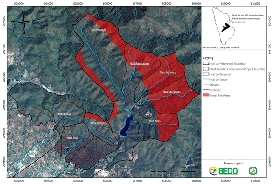
This research aimed to develop a geospatial database to support biodiversity and ecosystem conservation within the area of the Plant Genetic Conservation Project under the Royal Initiative of Her Royal Highness Princess Maha Chakri Sirindhorn, located in Pa Phai sub-district, San Sai district, Chiang Mai. A Participatory Action Research (PAR) approach was employed, involving multiple stakeholders and integrating scientific and technological knowledge with local wisdom. The study focused on organizing a spatial information system to assess the status, potential, and limitations of biological factors and to identify indicators related to the stability of biodiversity and eco-cultural landscapes. Spatial data analysis revealed that the headwater forest area of the Huai Jo Low Hill watershed had the potential to generate approximately 2.35x 10⁶ m3 yr-1 of streamflow annually and to contribute an estimated annual income of about 2,000,000 Baht to surrounding communities. The area also holds significant ecological value for conservation-based recreation and research activities. However, the stability of biodiversity is threatened by intensive land use, particularly forest product gathering influenced by the local belief that forest burning promotes plant regrowth. Furthermore, unregulated recreational activities negatively affect the watershed’s ecological, economic, social, and research functions, pushing the ecosystem toward a regression stage. To address these challenges, conservation, restoration, and management strategies should be guided by the principles of Integrated Watershed Management (IWM), including landscape zoning; for sustainable resource use; designation of preservation and conservation-development zones, and enforcement of appropriate laws, regulations, and management measures. To support these efforts, three types of databases were developed: (1) a GIS-based spatial database, (2) an information database, and (3) a Google Earth platform database integrated with up-to-date satellite imagery. These tools facilitate effective communication of research findings to communities, researchers, and administrative platforms at various levels.
References
Maejo University Farm Office. n.d. Ban Pong Development Project under the Royal Initiative, Maejo University. Retrieved from https://royal.mju.ac.th/goverment/25660621094007_royalmju/Doc_25670118112459_100104.pdf [in Thai]
Mingthipol, O., U. Thammapanya and S. Hongwittayakorn. 2018. Development of a Geographic Information Database to Support the Conservation of Biodiversity and the Ecosystem of the Huai Cho Foothills Basin. Bangkok: Faculty of Architecture and Environmental Design, Maejo University. 153 p. [in Thai]
Office of Bioeconomy Development. 2018. Local Biodiversity Management Manual. Bangkok: Suea Tawan Publishing House. 135 p. [in Thai]
Office of the Special Committee for Coordination of Royal Initiative Projects. 1993. Theory of Forest Restoration Development under Royal Initiatives. Retrieved from https://www.rdpb.go.th/th/home [in Thai]
Schwarz, N., M. Moretti, M. Bugalho, Z. Davies, D. Haase, J. Hack, A. Hof, Y. Melero, T. Pett and S. Knapp. 2017. Understanding biodiversity-ecosystem service relationships in urban areas: a comprehensive literature review. Ecosystem Services 27: 161–171.
Upper Northern Irrigation Hydrological Center. 2024. Rainfall conditions. Retrieved from https://hydro-1.net/ [in Thai]
Weiskopf, S., B. Myers, M. Arce-Plata, J. Blanchard, S. Ferrier, E. Fulton, M. Harfoot, F. Isbell, J. Johnson, A. Mori, E. Weng, Z. HarmáCˇková, M. Londoño-Murcia, B. Miller, L. Pereira and I. Rosa. 2022. A conceptual framework to integrate biodiversity, ecosystem function, and ecosystem service models. Bioscience 72: 1062–1073.
Downloads
Published
How to Cite
Issue
Section
License
Copyright (c) 2026 Journal of Agricultural Research and Extension

This work is licensed under a Creative Commons Attribution-NonCommercial-NoDerivatives 4.0 International License.
This article is published under a Creative Commons Attribution-NonCommercial-NoDerivatives 4.0 International License (CC BY-NC-ND 4.0), which allows others to share the article with proper attribution to the authors and prohibits commercial use or modification. For any other reuse or republication, permission from the journal and the authors is required.

