การใช้ดัชนีพืชพรรณ (NDVI) ร่วมกับดัชนีความต่างความชื้นของพืช (NDMI) เพื่อศึกษาผลกระทบที่เกิดขึ้นจากไฟป่าในพื้นที่ป่าไม้ ด้วยภาพถ่ายดาวเทียม Senitel-2 กรณีศึกษา ป่าสงวนแห่งชาติจังหวัดแพร่
DOI:
https://doi.org/10.14456/jare-mju.2026.31คำสำคัญ:
ทรัพยากรป่าไม้ , ป่าอนุรักษ์ , ป่าสงวน , ผลกระทบของไฟป่าบทคัดย่อ
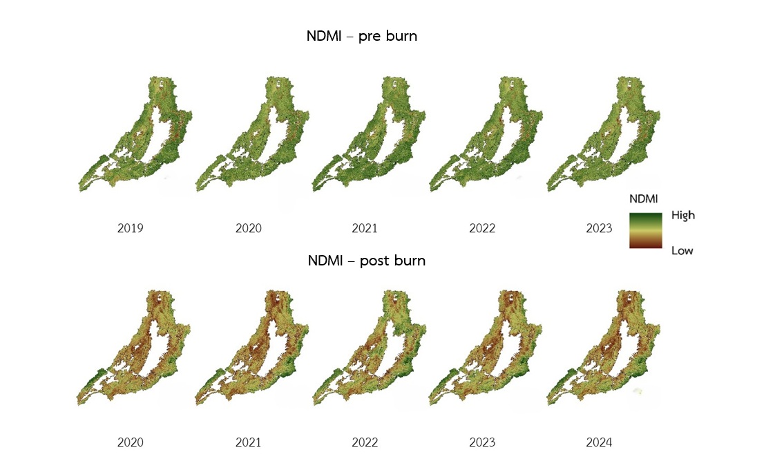
การศึกษาครั้งนี้มีวัตถุประสงค์เพื่อ 1) วิเคราะห์การเปลี่ยนแปลงดัชนีพืชพรรณ (Normalized Difference Vegetation Index: NDVI) และดัชนีความต่างของความชื้นของพืช (Normalized Difference Moisture Index: NDMI) ก่อนและหลังการเกิดไฟป่า 2) เพื่อจำแนกพื้นที่ที่ได้รับผลกระทบจากไฟป่า โดยการใช้ข้อมูลภาพถ่ายดาวเทียม Sentinel-2 กรณีศึกษา ป่าสงวนแห่งชาติจังหวัดแพร่ ช่วงเวลาก่อนและหลังเกิดไฟป่า กำหนดช่วงเวลา 5 ปี ตั้งแต่ปี พ.ศ. 2562–2567 ผลการศึกษาพบว่า ดัชนีพืชพรรณก่อนเกิดไฟป่ามีค่าเฉลี่ยอยู่ในช่วงประมาณ 0.50 ถึง 0.52 และหลังเกิดไฟป่ามีค่าเฉลี่ยอยู่ในช่วงประมาณ 0.27 ถึง 0.30 เมื่อวิเคราะห์การเปลี่ยนแปลงของดัชนีพืชพรรณ (dNDVI) พบว่า มีค่าเฉลี่ยอยู่ในช่วงประมาณ 0.14 ถึง 0.25 ซึ่งหมายถึงการลดลงของค่าความเขียวของพืชพรรณอย่างมีนัยสำคัญ สอดคล้องกับการวิเคราะห์ดัชนีความต่างของความชื้นของพืชพบว่า ก่อนเกิดไฟป่ามีค่าเฉลี่ยเท่ากับ 0.17 ถึง 0.51 และหลังจากเกิดไฟป่าพบว่า มีค่าเฉลี่ยเท่ากับ 0.03 ถึง -0.03 บ่งชี้ถึงการสูญเสียความชื้นในพืชพรรณอันเกิดจากกระบวนการเผาไหม้และการระเหยของน้ำในเรือนยอด เมื่อพิจารณาการเปลี่ยนแปลงดัชนีความต่างของความชื้นของพืช (dNDMI) มีค่าการเปลี่ยนแปลงอยู่ในช่วง 0.18 ถึง 0.48 ซึ่งพบการสูญเสียความชื้นของพืชพรรณอย่างมากในบริเวณที่ได้รับผลกระทบโดยตรงจากไฟป่า สอดคล้องกับการประเมินความถูกต้องของผลการแปลภาพพื้นที่เกิดไฟไหม้ด้วยภาพถ่ายดาวเทียม Sentinel-2 พบว่า มีค่าความถูกต้องโดยรวม (overall accuracy) และสัมประสิทธิ์แคปปา (Kappa coefficient) เท่ากับร้อยละ 92.99 และ 0.83 ตามลำดับ สะท้อนความแม่นยำของการจำแนกภาพในระดับดีมาก
เอกสารอ้างอิง
Arruda, L.S.V., J.V. Piontekowski, A. Alencar, S.P. Reginaldo and A.T.E. Matricardi. 2021. An alternative approach for mapping burn scars using landsat imagery, Google Earth Engine, and deep learning in the Brazilian Savanna. Remote Sensing Applications: Society and Environment 22(2021): 100472. https://doi.org/10.1016/j.rsase.2021.100472
Bilal, M. 2025. Spectral indices alone are not enough: a critical assessment of pre-fire forest fires risk mapping. Ecological Informatics 91(2025): 103435.
Choya, A., S. Tuprakay, P. Premanoch and M. Ratcha 2025. Health risk assessment from inhalation exposure to PM2.5 among adults groups in the upper northern region of Thailand. Journal of Faculty of Public Health, Ubon Ratchathani Rajabhat University 14(1): 55–65. [in Thai]
Geo-Informatics and Space Technology Development Agency (Public Organization). 2025. Five-year historical hot spot statistics. Retrieved from https://www.gistda.or.th/news_view.php?n_id=5688&lang=TH [in Thai]
Kelp, M., M. Burke, M. Qiu, I. Higuera-Mendieta, T. Liu, N.S. Diffenbaugh. 2025. Effect of recent prescribed burning and land management on wildfire burn severity and smoke emissions in the Western United States. AGU Advances 6(3): e2025AV001682 https://doi.org/10.1029/2025AV001682
Konpian, S., J. Som-ard, W. Jitsukka and S.R. Suwanlee. 2020. Assessment of forest recovery at conservation areas in Loei province using landsat imagery in time series. Thai Science and Technology Journal 28(7): 1185–1201. [in Thai]
Linta, N., N. Mahavik, S. Chatsudarat, K. Seecjata and A. Yodying. 2021. Analysis of burning area from forest fire using Sentinel-2 image: a case study of Pai, Mae Hong Son province. Journal of Applied Informatics and Technology 3(2): 101–121. [in Thai]
Mushayi, M.M., S. Kusangaya and N. Mujere. 2023. Use of remote sensing to determine rainwater harvesting sites for piped micro-irrigation schemes in Chimanimani district. Zimbabwe. Water SA. 49(1): 56–63. https://doi.org/10.17159/wsa/2023.v49.i1.3943.
Obpaet, A., P. Thongchap, W. Suksinuan and A. Yiba. 2021. Analysis of Wildfire Severity Using Sentinel-2 Satellite Imagery: A Case Study of Doi Suthep-Pui National Park. pp. SGI-07-1-8. In Proceedings of the 26th National Civil Engineering Conference 23–25 June 2021. Bangkok: Civil Engineering and Beyond the Limit Development. [in Thai]
Oonban, P. and K. Deeudomchan. 2023. Analyzing frequency and burned area extraction implement of Google Earth Engine platform. The Journal of Spatial Innovation Development 4(2): 93–110. [in Thai]
Pereira, J.M.C., E. Chuvieco, A. Beaudoin and N. Desbois. 1997. Remote Sensing of Burned Areas: A Review Remote Sensing of Environment. pp. 127–184. In Chuvieco, E. (Eds.). A Review of Remote Sensing Methods for the Study of Large Wildland Fires. Spain: Impreso en España.
Phrae Provincial Office of Natural Resources and Environment. 2024. Provincial Natural Resources and Environment Management Plan, Phrae Province (2023–2027). Phare: Phrae Provincial Office of Natural Resources and Environment. 137 p. [in Thai]
Pinto, M.M., R.M. Trigo, I.F. Trigo and C.C. DaCamara. 2021. A practical method for high-resolution burned area monitoring using Sentinel-2 and VIIRS. Remote Sensing 13(9): 1608. https://doi.org/10.3390/rs13091608
RECOFTC. 2024. Community-based Fire Management (CBFiM) in Thailand. RECOFTC, Bangkok, Thailand. Retrieved from https://www.recoftc.org/publications/community-based-fire-management-thailand [in Thai]
Roy, D.P., Y. Jinb, P.E. Lewisc and C.O. Justiceb. 2005. Prototyping a global algorithm for systematic fire-affected area mapping using MODIS time series data. Remote Sensing of Environment 97(2): 137–162.
Ruthamnong, S. 2019. Burned area extraction using multitemporal difference of spectral indices from Landsat 8 data: a case study of Khlong Wang Chao, Klong Lan and Mae Wong National Park. The Golden Teak: Humanity and Social Science Journal (GTHJ) 25(2): 49–65.
Veraverbeke, S., S. Lhermitte, W. Verstraeten and R. Goossens. 2010. Assessing Burn Severity Using Satellite Time Series. pp. 107–118. In Brebbia, C.A. and G. Perona (Eds.). Modelling, Monitoring and Management of Forest Fires II. Southampton: WIT Press. https://doi.org/10.2495/FIVA100101
Volcani, A., A. Karnieli and T. Svoray. 2005. The use of remote sensing and GIS for spatio-temporal analysis of the physiological state of a semi-arid forest with respect to drought years. Forest Ecology and Management 215(1-3): 239–250. https://doi.org/10.1016/j.foreco.2005.05.063
ดาวน์โหลด
เผยแพร่แล้ว
รูปแบบการอ้างอิง
ฉบับ
ประเภทบทความ
สัญญาอนุญาต
ลิขสิทธิ์ (c) 2026 วารสารวิจัยและส่งเสริมวิชาการเกษตร

อนุญาตภายใต้เงื่อนไข Creative Commons Attribution-NonCommercial-NoDerivatives 4.0 International License.
บทความนี้ได้รับการเผยแพร่ภายใต้สัญญาอนุญาต Creative Commons Attribution-NonCommercial-NoDerivatives 4.0 International (CC BY-NC-ND 4.0) ซึ่งอนุญาตให้ผู้อื่นสามารถแชร์บทความได้โดยให้เครดิตผู้เขียนและห้ามนำไปใช้เพื่อการค้าหรือดัดแปลง หากต้องการใช้งานซ้ำในลักษณะอื่น ๆ หรือการเผยแพร่ซ้ำ จำเป็นต้องได้รับอนุญาตจากวารสาร