Application of Vegetation Index (NDVI) and Normalized Difference Moisture Index (NDMI) to Study the Impacts of Wildfires in Forest Areas Using Sentinel-2 Satellite Imagery: A Case Study of National Reserves Forest, Phrae Province
DOI:
https://doi.org/10.14456/jare-mju.2026.31Keywords:
forest resources, conserved forest, protected forest, the impacts of forest firesAbstract
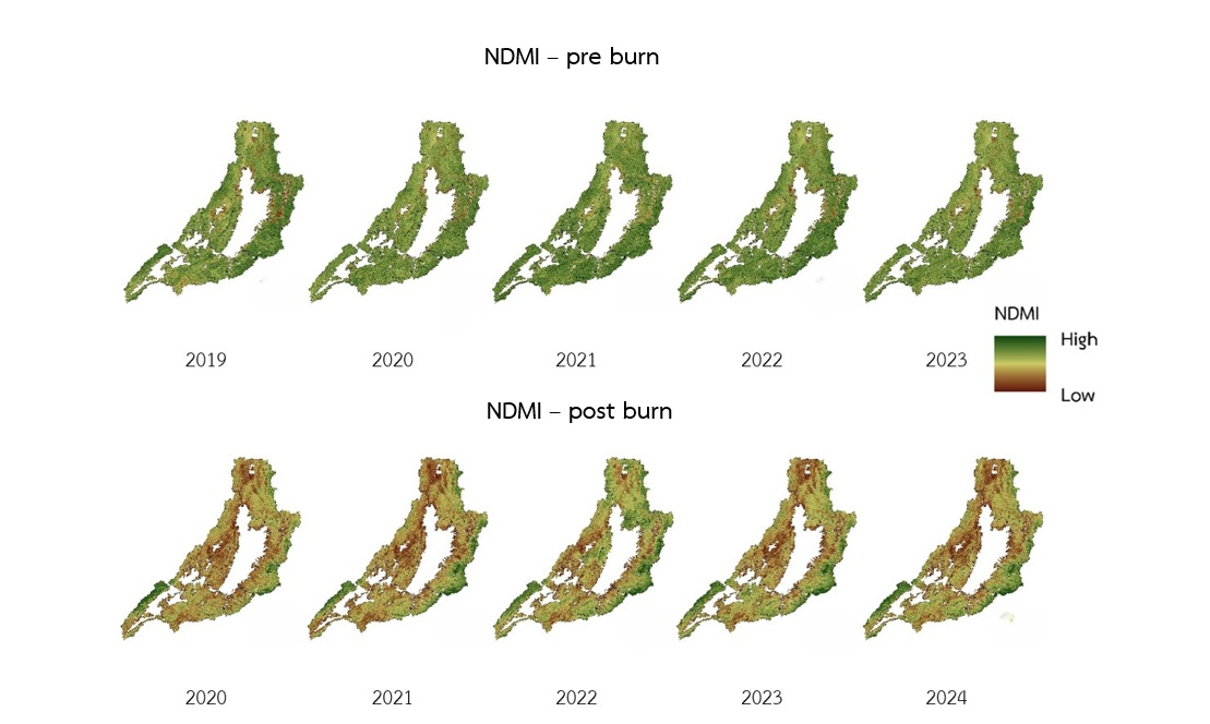
The objectives of this study were: (1) to analyze changes in the Normalized Difference Vegetation Index (NDVI) and the Normalized Difference Moisture Index (NDMI) before and after forest fire events; and (2) to classify areas affected by forest fires using Sentinel-2 satellite imagery. The study was conducted in Phrae National Reserved Forest, Thailand, over a five-year period from 2019 to 2024. The results revealed that average NDVI values prior to forest fire occurrences ranged from approximately 0.50 to 0.52, whereas post-fire NDVI values declined to between 0.27 and 0.30. The difference in NDVI (dNDVI) ranged from 0.14 to 0.25, indicating a statistically significant decrease in vegetation greenness. Correspondingly, the mean NDMI values before the forest fires ranged from 0.17 to 0.51, while post-fire NDMI values declined to between 0.03 and -0.03, reflecting a substantial loss of vegetation moisture. This reduction is attributed to combustion processes and the evaporation of canopy water resulting from the forest fires. Analysis of NDMI change (dNDMI) further demonstrated variation between 0.18 and 0.48, highlighting severe vegetation moisture loss in areas directly impacted by fire. Accuracy assessment of the burned-area classification derived from Sentinel-2 imagery yielded an overall accuracy of 92.99% and a Kappa coefficient of 0.83, suggesting a high level of classification reliability.
References
Arruda, L.S.V., J.V. Piontekowski, A. Alencar, S.P. Reginaldo and A.T.E. Matricardi. 2021. An alternative approach for mapping burn scars using landsat imagery, Google Earth Engine, and deep learning in the Brazilian Savanna. Remote Sensing Applications: Society and Environment 22(2021): 100472. https://doi.org/10.1016/j.rsase.2021.100472
Bilal, M. 2025. Spectral indices alone are not enough: a critical assessment of pre-fire forest fires risk mapping. Ecological Informatics 91(2025): 103435.
Choya, A., S. Tuprakay, P. Premanoch and M. Ratcha 2025. Health risk assessment from inhalation exposure to PM2.5 among adults groups in the upper northern region of Thailand. Journal of Faculty of Public Health, Ubon Ratchathani Rajabhat University 14(1): 55–65. [in Thai]
Geo-Informatics and Space Technology Development Agency (Public Organization). 2025. Five-year historical hot spot statistics. Retrieved from https://www.gistda.or.th/news_view.php?n_id=5688&lang=TH [in Thai]
Kelp, M., M. Burke, M. Qiu, I. Higuera-Mendieta, T. Liu, N.S. Diffenbaugh. 2025. Effect of recent prescribed burning and land management on wildfire burn severity and smoke emissions in the Western United States. AGU Advances 6(3): e2025AV001682 https://doi.org/10.1029/2025AV001682
Konpian, S., J. Som-ard, W. Jitsukka and S.R. Suwanlee. 2020. Assessment of forest recovery at conservation areas in Loei province using landsat imagery in time series. Thai Science and Technology Journal 28(7): 1185–1201. [in Thai]
Linta, N., N. Mahavik, S. Chatsudarat, K. Seecjata and A. Yodying. 2021. Analysis of burning area from forest fire using Sentinel-2 image: a case study of Pai, Mae Hong Son province. Journal of Applied Informatics and Technology 3(2): 101–121. [in Thai]
Mushayi, M.M., S. Kusangaya and N. Mujere. 2023. Use of remote sensing to determine rainwater harvesting sites for piped micro-irrigation schemes in Chimanimani district. Zimbabwe. Water SA. 49(1): 56–63. https://doi.org/10.17159/wsa/2023.v49.i1.3943.
Obpaet, A., P. Thongchap, W. Suksinuan and A. Yiba. 2021. Analysis of Wildfire Severity Using Sentinel-2 Satellite Imagery: A Case Study of Doi Suthep-Pui National Park. pp. SGI-07-1-8. In Proceedings of the 26th National Civil Engineering Conference 23–25 June 2021. Bangkok: Civil Engineering and Beyond the Limit Development. [in Thai]
Oonban, P. and K. Deeudomchan. 2023. Analyzing frequency and burned area extraction implement of Google Earth Engine platform. The Journal of Spatial Innovation Development 4(2): 93–110. [in Thai]
Pereira, J.M.C., E. Chuvieco, A. Beaudoin and N. Desbois. 1997. Remote Sensing of Burned Areas: A Review Remote Sensing of Environment. pp. 127–184. In Chuvieco, E. (Eds.). A Review of Remote Sensing Methods for the Study of Large Wildland Fires. Spain: Impreso en España.
Phrae Provincial Office of Natural Resources and Environment. 2024. Provincial Natural Resources and Environment Management Plan, Phrae Province (2023–2027). Phare: Phrae Provincial Office of Natural Resources and Environment. 137 p. [in Thai]
Pinto, M.M., R.M. Trigo, I.F. Trigo and C.C. DaCamara. 2021. A practical method for high-resolution burned area monitoring using Sentinel-2 and VIIRS. Remote Sensing 13(9): 1608. https://doi.org/10.3390/rs13091608
RECOFTC. 2024. Community-based Fire Management (CBFiM) in Thailand. RECOFTC, Bangkok, Thailand. Retrieved from https://www.recoftc.org/publications/community-based-fire-management-thailand [in Thai]
Roy, D.P., Y. Jinb, P.E. Lewisc and C.O. Justiceb. 2005. Prototyping a global algorithm for systematic fire-affected area mapping using MODIS time series data. Remote Sensing of Environment 97(2): 137–162.
Ruthamnong, S. 2019. Burned area extraction using multitemporal difference of spectral indices from Landsat 8 data: a case study of Khlong Wang Chao, Klong Lan and Mae Wong National Park. The Golden Teak: Humanity and Social Science Journal (GTHJ) 25(2): 49–65.
Veraverbeke, S., S. Lhermitte, W. Verstraeten and R. Goossens. 2010. Assessing Burn Severity Using Satellite Time Series. pp. 107–118. In Brebbia, C.A. and G. Perona (Eds.). Modelling, Monitoring and Management of Forest Fires II. Southampton: WIT Press. https://doi.org/10.2495/FIVA100101
Volcani, A., A. Karnieli and T. Svoray. 2005. The use of remote sensing and GIS for spatio-temporal analysis of the physiological state of a semi-arid forest with respect to drought years. Forest Ecology and Management 215(1-3): 239–250. https://doi.org/10.1016/j.foreco.2005.05.063
Downloads
Published
How to Cite
Issue
Section
License
Copyright (c) 2026 Journal of Agricultural Research and Extension

This work is licensed under a Creative Commons Attribution-NonCommercial-NoDerivatives 4.0 International License.
This article is published under a Creative Commons Attribution-NonCommercial-NoDerivatives 4.0 International License (CC BY-NC-ND 4.0), which allows others to share the article with proper attribution to the authors and prohibits commercial use or modification. For any other reuse or republication, permission from the journal and the authors is required.


